
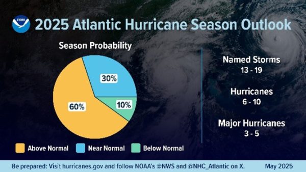
Looking back, 2024 was a big year for hurricanes. Monsters like Hurricane Milton brought heavy impacts to Florida, while Hurricane Helene devastated North Carolina with record rainfall and deadly floods. As people continue to recover from last year’s destructive hurricanes, they fear the next hurricane season to come. NOAA and many other hurricane experts and meteorologists held nothing back as they predicted another above-average hurricane season for 2025. This was because of the warmer-than-average sea surface temperatures, less wind shear, and a prediction of a neutral ENSO (El Niño-Southern Oscillation) climate pattern, (additional link).
The hurricane season officially began on June 1st, but the first named storm wouldn’t form until June 23rd with Tropical Storm Andrea, marking the latest start since 2014. Tropical Storms Barry and Chantal would soon follow, as Barry’s remnants brought the catastrophic flooding on July 4th in Texas, while Chantal made landfall in South Carolina and caused heavy flooding in that region.
A month would go by until the next named storm, Tropical Storm Dexter, brought little impact as it spun over the Atlantic Ocean. Soon after, Hurricane Erin formed and briefly reached Category 5 status, bringing impacts to Puerto Rico with its outer rainbands. The rest of the season would remain inactive until the most recent and present systems, Hurricane Gabrielle and Tropical Storm Humberto emerged. Hurricane Gabrielle is expected to become a Category 2 hurricane at its peak. Invest 94L is a potential development region that may form into a tropical storm or hurricane that may bring some impacts to the East Coast within the next week.
So far, the 2025 hurricane season has been below average, with only seven named storms and two hurricanes, although both were major hurricanes. The reason for this was the unfavorable atmospheric conditions in the Atlantic Ocean and the Gulf of Mexico. Warm ocean temperatures, an unstable and moist atmosphere, and low wind shear must be present for tropical systems to form. However, for most of the season, especially during the peak in early September, there has been little tropical activity. Factors like heavy wind shear over the Gulf of Mexico and the Caribbean, as well as the Sahara Dust which has been blown over into the Atlantic, have significantly limited the tropical activity this season. Even when there have been strong hurricanes, a weak Bermuda High has kept the storms out at sea.
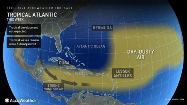
Dry, dusty air along with strong wind shear has limited the formation of many tropical systems this year.
Although we have passed the peak of hurricane season, it is still far from over. Hurricane Gabrielle and Tropical Storm Humberto continue to churn in the Atlantic, and there are many other regions highlighted for potential tropical development. As the season progresses, you can listen to and find information from various weather agencies like NOAA, The Weather Channel, AccuWeather, and Max Velocity as they are all good, reliable sources.
Top 5 Storms … So Far:
- Tropical Storm Fernand – Officially forming into a tropical system on August 23rd, Fernand reached a peak intensity of 60mph sustained winds and a pressure of 1000mbar. It eventually spun out in the Atlantic, east of Bermuda, dissipating on August 27th.
- Tropical Storm Barry – Forming over the Yucatán Peninsula on June 28th, Barry reached a peak intensity of 45mph sustained winds and a pressure of 1006mbar, making landfall near Tampico, Mexico. The remnants of Barry also caused the formation of the intense thunderstorms responsible for the catastrophic July 4th Texas Floods.
- Tropical Storm Chantal – Forming off the east coast of Florida, Chantal reached a peak intensity of 60mph sustained winds and a pressure of 1002mbar. On the week of July 5th, Chantal made landfall in South Carolina, causing major flooding, six fatalities, and millions of dollars of damage.
- Hurricane Gabrielle (Cat 4) – Forming from a tropical wave from Africa, Gabrielle organized into a tropical storm on September 17th but struggled to gain strength due to the poor atmospheric conditions. However, Gabrielle reached a more conducive environment and rapidly intensified from a Category 1 to a Category 4 storm overnight on September 21st, reaching a peak intensity of 140mph sustained winds and a pressure of 948mbars. It is currently a Category 3 storm traveling east across the Atlantic.
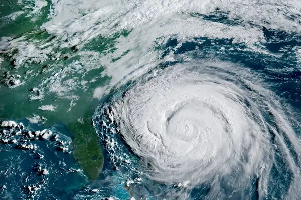
- Hurricane Erin (Cat 5) – After crossing the Cape Verde islands, Erin formed into a tropical storm on August 11th, slowly strengthening into a Category 2 storm across the Atlantic. While just north of the Leeward Islands, Erin rapidly intensified into a Category 5 monster before weakening back to a Category 2 as it turned north. In all, Erin caused nine fatalities in Cape Verde, flooding and power outages in Puerto Rico, an extreme surge, beach erosion, and coastal flooding to the Outer Banks of North Carolina.
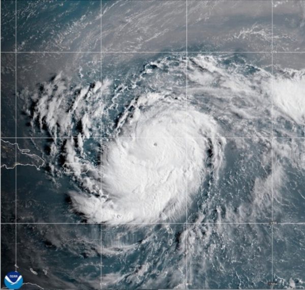
Hurricane Erin as a Category 5 monster.
Rankings and information dated as of September 24th, 2025 at 9 PM CDT.
https://en.wikipedia.org/wiki/2025_Atlantic_hurricane_season